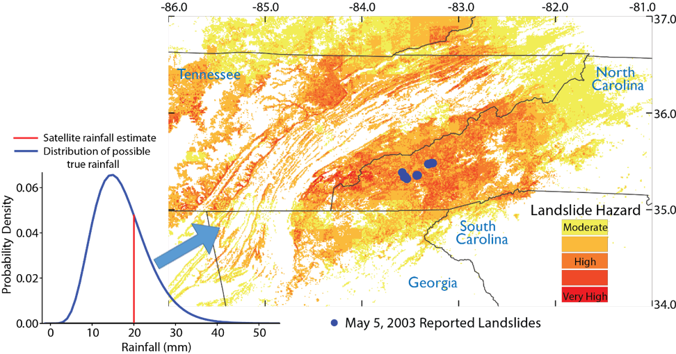
Satellite rainfall datasets, such as the IMERG product from NASA, use remote sensing data gathered by satellites to estimate precipitation at the earth’s surface. Satellite-based global rainfall data is available to the public in near-real time and is a valuable resource for a variety of applications, from flood modeling and water resource management to drought monitoring and landslide hazard assessment. However, due to intermittent satellite coverage and imperfect algorithms that translate remote sensing data to rainfall values, satellite rainfall products can contain considerable errors, especially at high latitudes, over mountainous terrain, and during heavy rainfall events. Uncertainty in satellite rainfall data limits the use of this data. Most models that use satellite rainfall data don’t currently account for the uncertainty inherent in this data, which may lead to uncertainty in model output (i.e. flood level estimates, landslide hazard).
This research seeks to incorporate satellite rainfall uncertainty into different types of hazard models and to understand the implications for hazard prediction. Consider, for example, NASA’s Landslide Hazard Assessment for Situational Awareness (LHASA) model, which assesses rainfall-triggered landslide hazard around the world in near real-time using NASA’s IMERG product. We developed a probabilistic adaption of the LHASA model, demonstrating one way to account for IMERG uncertainty and improving model performance. We are exploring how satellite rainfall error can be characterized in regions with limited ground-based rainfall data (such as rain gauges or radar) and how to preserve spatial and temporal patterns of rainfall when accounting for satellite rainfall uncertainty.